|
|
| Zentralargentinien
- Von Mendoza bis Bariloche: |
| Leider
hatten wir bisher noch nicht Gelegenheit, diese Seite ins
Deutsche zu übersetzen. Bei eventuellen Fragen können
Sie sich aber an uns wenden. |
| |
|
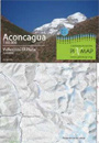
Aconcagua
(Argentina)
72
x 55 / 19,5 x 12,5 cms.
Ch$
6.000 |
Side
1: Mount Aconcagua main massive, shows the different
ascent routes - Mountaineering; 1:60.000, contour interval
is 25 m
Side 2: The whole Cordón del Plata, in the surroundings
of the ski center Vallecitos, a popular spot to get
aclimate before climbing Aconcagua. With the routes
to the hills Agustín Álvarez, Rincón,
Vallecitos, Negro and Plata (5930 msnm).
Mountaineering; 1:50.000, contour interval is 25 m
 |
|
Aconcagua
1:25.000 -
Parque Provincial Aconcagua
(Argentina)
42,5
x 60 / 21,5 x 12,5 cms.
Ch$
6.000 |
Lado
1: Macizo central del Cerro Aconcagua, con diferentes
rutas de ascenso. Río Horcones Superior, Plaza
de Mulas; Campamentos y refugios.
Montañismo 1:25.000, equidistancia curvas nivel
25 m
Lado 2: Parque Provincial Aconcagua, entre Punta de
Vacas, Las Cuevas y el Límite Internacional.
Senderismo, 1:100.000, equidistancia curvas nivel 25
m
 |
|
Ruta
de los 7 Lagos
San Martín al Vn. Lanín
(Argentina)
60
x 42,5 / 21,5 x 12,5 cms.
Ch$
7.000 |
Side 1: From lake Lacar to Nahuelhuapi, San Martín
de los Andes, Villa Angostura, Villa and lake Truful,
Confluencia
Side 2: From Lanin volcano to San Martín de los
Andes with the lakes Tromen, Paimún, Huechulafquén,
Currhué, Lolog and Lacar.
Shows several trekking routes.
Orientation,
Trekking 1:150.000, contour interval is 50 m
|
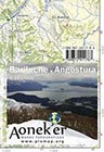 |
S.
C. de Bariloche y Villa La Angostura
(Argentina)
42,5
x 60 / 21,5 x 12,5 cms.
Ch$
7.000 |
Side 1: From lake Nahuel Huapi (Arm Blest) until lake
Guillermo, all of the central part of the NP Nahuel
Huapi with Mount Tronador, hills Negro and Catedral
with its trails, refuges, campsites and hostels.
Side 2: Northern part of lake Nahuel Huapi until the
lakes Traful and Espejo, from the Puyehue Pass (a.k.a
Samoré) until the confluence of the rivers Traful
and Cuyín Manzano. Shows many hotels and campsites
and also some trails.
General orientation, Trekking; 1:125.000
|
|
San
Carlos de Bariloche
(Argentina)
42,5
x 60 / 21,5 x 12,5 cms.
Ch$
6.000 |
Bariloche to Colonia Suiza with the hills Catedral,
López, Negro and Cuernos del Diablo; trails to
the Traverse Nahuel Huapi from Villa Catedral - Refugio
Jakob - Refugio Laguna Negra (Segre) - Colonia Suiza
Trekking; 1:50.000, contour interval is 25 m
|
|
Monte
Tronador
Paso de las Nubes
(Argentina)
42,5
x 60 / 21,5 x 12,5 cms.
Ch$
6.000 |
Mount Tronador with the ascent routes, trail "Paso
de las Nubes" between Pampa Linda and Puerto Frías;
plus the area of the hills Bonete, Capitán, Constitución
and Parque; arm Tristeza from the Lake Nahuelhuapi,
lagoons Frey, Ilón and Azul
Trekking;
1:50.000, contour interval is 25 m
|
| |
|
|
|
| |
|