|
Mapa
de Chile
100
x 70 / 27 x 11,5 cms.
Ch$
8.000 |
Entire
Chile in a plastified map, without relief but with contour
levels.
Side 1: From Visviri to Temuco, in 2 stripes.
Side 2: From Freire to Puerto Natales in 2 stripes,
Punta Arenas and Tierra del Fuego in a insert.
Road map, 1:1.300.000

|
|
Chiletur
Copec CHILE
Spafax, 2023
Spanish
22
x 12,5 cms./ 640 pags.
Ch$
11.000 |
Tourist guide for the whole of Chile, collects the information from the North, Center and South volumes. It includes road maps of all of Chile (scales from approx. 1: 600,000 to 1: 1,100,000), hotel list, restaurants, attractions and services in general. |
|
Chiletur
Copec Rutas
Spafax, 2023
Spanish
22
x 12,5 cms./ 112 pags.
Ch$
4.000 |
Road map of all Chile. It divides the country into 20 strips from north to south. Scales between approximately 1:850,000 (central area) to 1:1,700,000 (North) and 1:2,000,000 (Extreme South).
60 pages with a description of the 100 main tourist attractions in the different regions. |
|
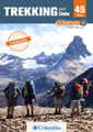
Chiletur
Trekking
Ladera Sur, 2023
Spanish
18
x 12 cms./ 216 pags.
Ch$
9.500 |
A new guide prepared by the Ladera Sur team that presents 25 different routes, between the Lauca NP to Isla Navarino, each one with general information, route description, photographs, height profile and a map. Most of them are excursions for the day, but also some multi-day-hikes are described, such as Tantauco, Cerro Castillo or Torres del Paine. |
|
Trekking
por Chile
M.Osandón - J.Gardeweg -
Editorial Compass 2019
Spanish
20
x 13 cms./ 192 pages
Ch$ 17.000
|
This
trekking guide covers 45 routes of Chile from north
to south, with a selection of the best trails. It goes
from Parque Nacional del Lauca to Cabo Froward, south
of Punta Arenas.
It has chapters for those who are starting this acitvity,
and also advice for the experts. There is also a section
about the flora and fauna you will find in the trails.
It has complete maps and photos of each of the treks,
and videos that you can discharge with a QR code.
See an example of a trek > |
|
Physical Map of Chile
140
x 40 cms / rolled
Ch$
19.900 |
Entire
Chile in a long wall map. Shows relief, the main cities,
regional boundaries and protected areas. Printed on
stone paper with metallic support at both ends for easy
hanging.
Escala aprox 1:3.000.000
|
|
Mapa
de Chile
Aborigines
140
x 40 cms / rolled
Ch$
19.900 |
Map of Chile showing the main original inhabitants of Chile. Contains illustrations of the aborigines from north to south with elements that highlight their customs, traditions and culture Printed on stone paper with metallic support
at both ends for easy hanging.
Escala aprox 1:3.000.000
|
|
Aves
de Chile
Mapa Biogegráfico
Planeta Sostenible
120
x 31 / 40 x 31 cms.
Ch$
10.300
|
Wall map containing 69 typical birds associated with the ecoregions where they are distributed. It includes information about its habitat and conservation status.
|
|
Animales
de Chile
Mapa Biogegráfico
Planeta Sostenible
120
x 31 / 40 x 31 cms.
Ch$
10.300
|
Wall map that contains illustrations of more than 90 animals of associated with the ecoregions where they live. Includes common name, scientific name and its distribution throughout Chile.
|
| |
|
|