|
|
| Antique
Maps: |
| These
are decorative maps, with cartographic representations of South
America from the 17th and 18th centuries. They are printed in
thick linen paper, which makes them easy to frame and hang on
the wall. |
| |
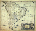
America
Pars Meridionalis, 1632
48
x 57 cms. / rolled
Ch$
6.000
|
Reproduction
of Southamerica of the year 1632. Names in Latin and
Dutch.
Printed in linen paper

|
| |
Carte
du Paraguy du Chili
51
x 60 cms. / rolled
Ch$
6.000 |
From
the paralel 18ºS (Arica) until Tierra del Fuego.
Representation from the 18th century. Names in French.
Printed
in linen paper
|
|
|